18,400 acres of bliss
The St. Regis Canoe Area is the only designated canoe area in the state. Paddlers can access the water at Long Pond, Upper St. Regis Lake, Hoel Pond, and Little Clear Pond, then it’s time to start exploring! There are 50 ponds totaling 1,621 acres that range in size from a half-acre unnamed pond to the 388-acre St. Regis Pond.
For a great sampler of what the area holds, try the popular Seven Carries canoe route, which goes from Little Clear Pond to Lower St. Regis Lake, passing through four ponds on the way to the end point at Paul Smith's College. The Nine Carries canoe route is another popular route that offers a couple of options. Before heading out, be aware that it is difficult to use wheeled canoe carriers on many of the trails, so be prepared to carry your gear when tackling a longer route.
More than water

Paddling is a major draw in the St. Regis Canoe Area, which is managed for its water resources, but outdoor enthusiasts will also find plenty of options for fishing, hunting, cross-country skiing, and snowshoeing. With so much to do, it’s easy to stay in a place like this for awhile, so why not take advantage of the region’s many primitive tent sites and lean-tos? There are 70 campsites located along the shores of 20 of the ponds here. All of designated primitive tents sites, campsites, and lean-tos are available on a first come, first served basis and can’t be reserved. Just look for a yellow "Camp Here" disc, and as long as it’s unoccupied you can start setting up camp. These are truly primitive sites, so you won’t find hook-ups for water or electricity.
Adventurous souls who want to set out on foot have 26 miles of trail to choose from, including St. Regis Mountain, Long Pond Mountain, and Fish Pond Truck Trail.
- Fish Pond Truck Trail: Long and easy, this path only ascends 200 feet in 4.7 miles, and there are a bunch of side trails to explore along the way.
- Long Pond Mountain: Paddle across Long Pond to reach the trailhead, then gain 930 feet in elevation over 1.5 miles to get to the top.
- St. Regis Mountain: This trail ascends more than 1,200 feet in 3.3 miles to the 35-foot restored fire tower on the mountain’s summit.
Winter
Just because the bodies of water of the canoe area are frozen doesn't mean it becomes a no-mans land. During the winter, snowshoeing and cross-country skiing take over. Use extreme care if crossing frozen waterbodies - something only experienced and prepared explorers should do. But even skipping the ice leaves plenty of short and not-so-short loops that can be skied or snowshoed.

Getting there
There are a number of ways to get into the St. Regis Canoe Area, including from the following parking areas:
Floodwood Road
- Floodwood Crossing parking area (44.3392° N, 74.4053° W)
- Long Pond parking area (44.3466° N, 74.4215° W)
- Hoel Pond hand launch parking area (44.3469° N, 74.3444° W)
Fish Hatchery Road
- Clear Pond Hand Launch Parking Area (44.3554° N, 74.2921° W)
- Fish Pond Truck Trail Parking Area (44.3554° N, 74.3037° W)
- Little Green Pond Parking Area (44.3592° N, 74.2946° W)
Town of Harrietstown Boat Launch - also sometimes referred to as the Upper St. Regis Lake boat launch (44.3951° N, 74.2698° W)
St. Regis Mountain trailhead parking area (44.4321° N, 74.3001° W)
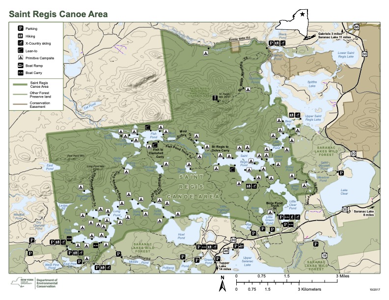
St Regis Canoe Area Map

A higher resolution St Regis Canoe Area map is also available for download.
Leave No Trace and Love Your ADK Pledge
The magic of the Adirondacks is the result of previous generations taking a long view and protecting the mountains, lakes, and rivers within the Blue Line. That tradition continues today as we support and encourage everyone to practice Leave No Trace ethics, which help protect the lands and waters of the Adirondacks.
Seven Principles of Leave No Trace

